
Selkirk Planning & Design

What We Do

Services

Selkirk Planning & Design works across the whole arc of a community plan, from the first conversation about what a place should become to the bylaw that makes it possible. Most projects draw on several of these at once.

Larch turning gold among dark conifers
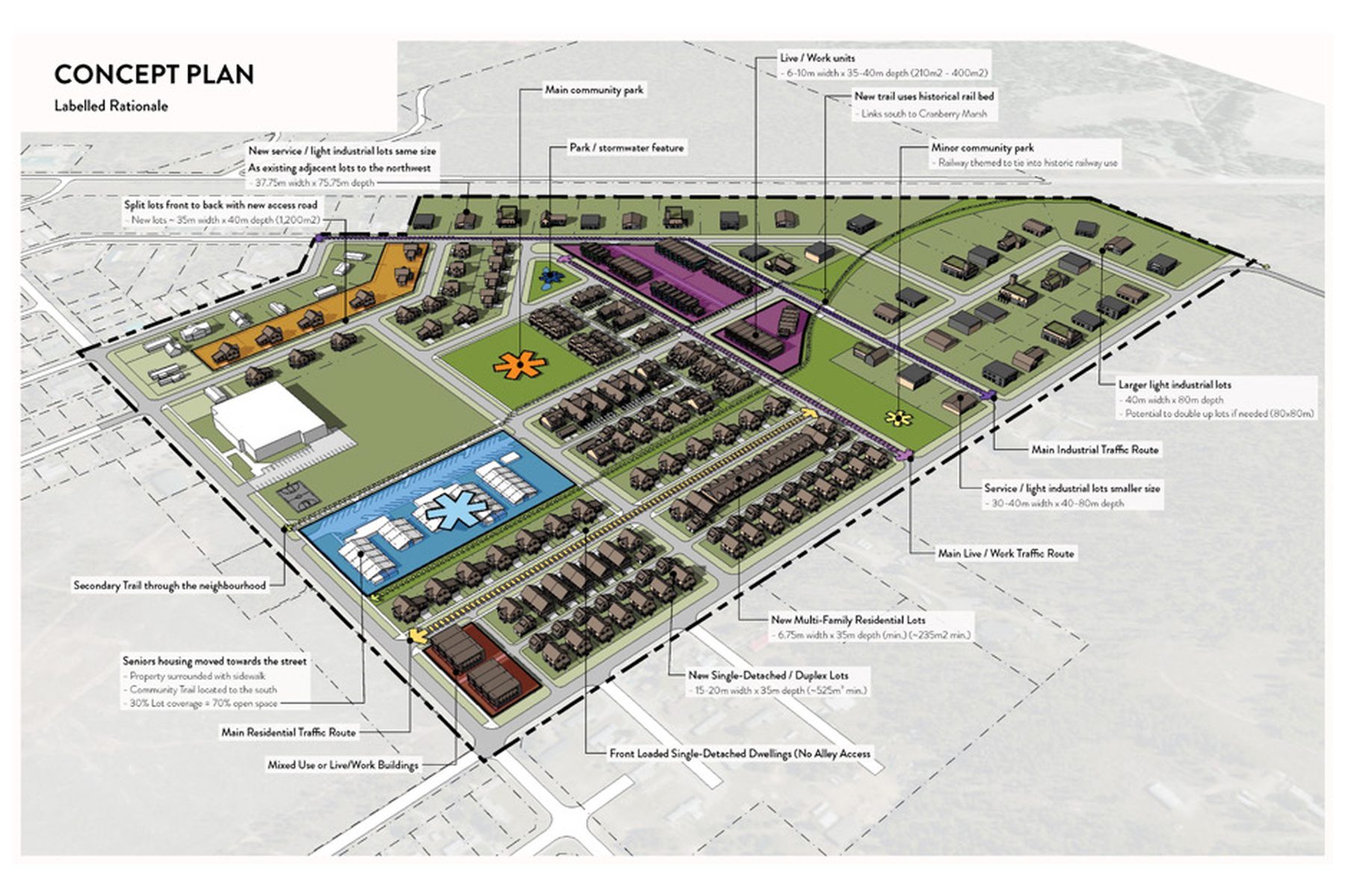
Labelled land use concept plan for Valemount

01

Official Community Plans & Zoning Bylaws

The rules a community grows by

An Official Community Plan sets out what a community wants to become, and the zoning bylaw is what turns that into something a building inspector can apply on a Tuesday morning. We write both, along with Development Permit Areas, and we write them to be used rather than admired.

Most plans fail quietly. They are adopted, shelved, and then contradicted one variance at a time, because the policies are either too vague to hold a line or too rigid to let the good project through. We convert narrative policy into single-sentence, action-oriented statements, so that staff, Council, and applicants all read the same intent and arrive at the same answer.

What you get

  • Official Community Plans
  • Zoning and form-based bylaws
  • Development Permit Areas and guidelines
  • Housing-legislation compliance review
  • Council workshops and adoption support
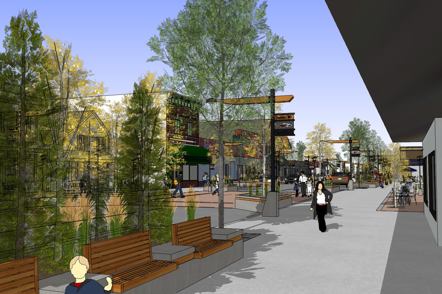
Street-level rendering of a redesigned 9th Street in Houston, BC

02

Urban Design

The scale a town is actually felt at

Streets, public spaces, and the buildings that frame them. Urban design is the work between the land use map and the building permit: how wide the sidewalk is, where the front door faces, whether the corner gets a patio or a parking aisle.

A mountain town's character lives at this scale, and it is lost at this scale too, usually not through one bad decision but through twenty small ones that nobody framed as a design question. Getting it right is also what makes a place walkable, and walkable places are more sociable, more sustainable, and cheaper to service.

What you get

  • Streetscape and public realm concepts
  • Form and character guidelines
  • Downtown revitalization plans
  • Illustrative plans and character sketches
  • Design review and redline comments
Master plan aerial of a passive-house neighbourhood

03

Master Planning

From raw ground to a place with an address

Neighbourhood and site master plans that set out how land will be used, how people will move through it, and what it will feel like once it is built. The master plan also considers costs, environmental performance, and provides answers about the number and types of units, green space, access, etc. that is key to a robust, well-developed plan. The work runs from site analysis through concept options to a plan a developer can finance and a Council can approve.

A master plan is where ambition meets slope, servicing, and arithmetic. We start with the landscape rather than the lot layout, because a plan that works with the terrain costs less to build and ages better. Each project is different because each site is different. At the end of the day the Master plan should reflect how the proposed development will add value to a neighbourhood, integrate with its settings, and achieve housing and unit options that work for everyone.

What you get

  • Site and constraints analysis
  • Concept options and testing
  • Final master plan and phasing
  • Density, unit yield, and land-use tables
  • 3D views and illustrative renderings
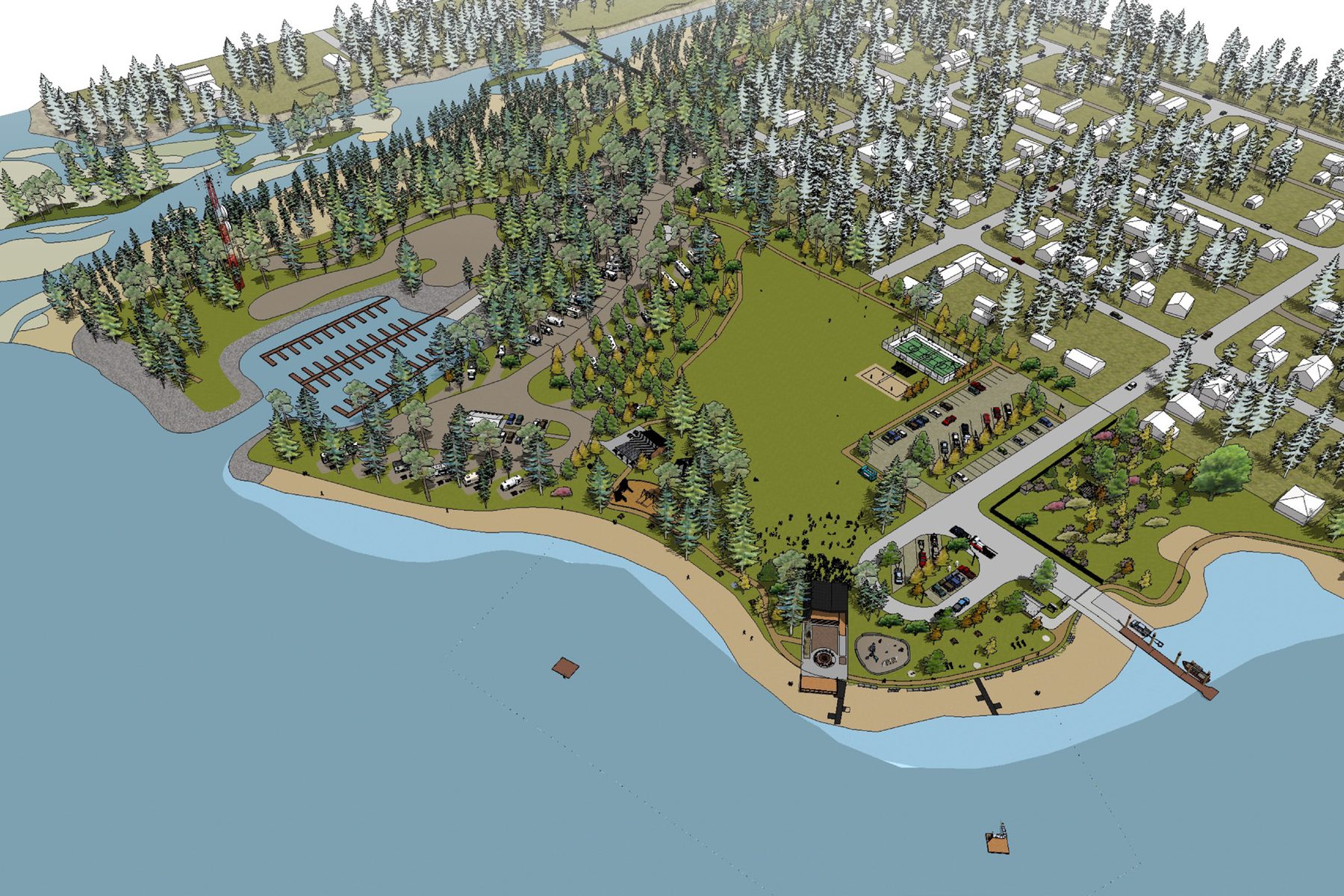
Aerial concept for Centennial Park in New Denver

04

Parks, Recreation & Trails

Where mountain towns spend their weekends

Park concepts, trail networks, and recreation strategies, from inventory and route planning through to concept design, cost, and phasing. We have mapped and planned trail systems from Canal Flats to Tumbler Ridge, including a network of 109 trails across a UNESCO Global Geopark.

Recreation is no longer a nice-to-have in a mountain community. It is the economy, it is the reason people move there, and it is the thing most likely to be loved to death without a plan behind it. A good strategy balances growth against conservation and says plainly what gets built first.

What you get

  • Trail inventory and network mapping
  • Parks and open space master plans
  • Recreation and destination strategies
  • Park concept designs and renderings
  • Costed, phased implementation plans
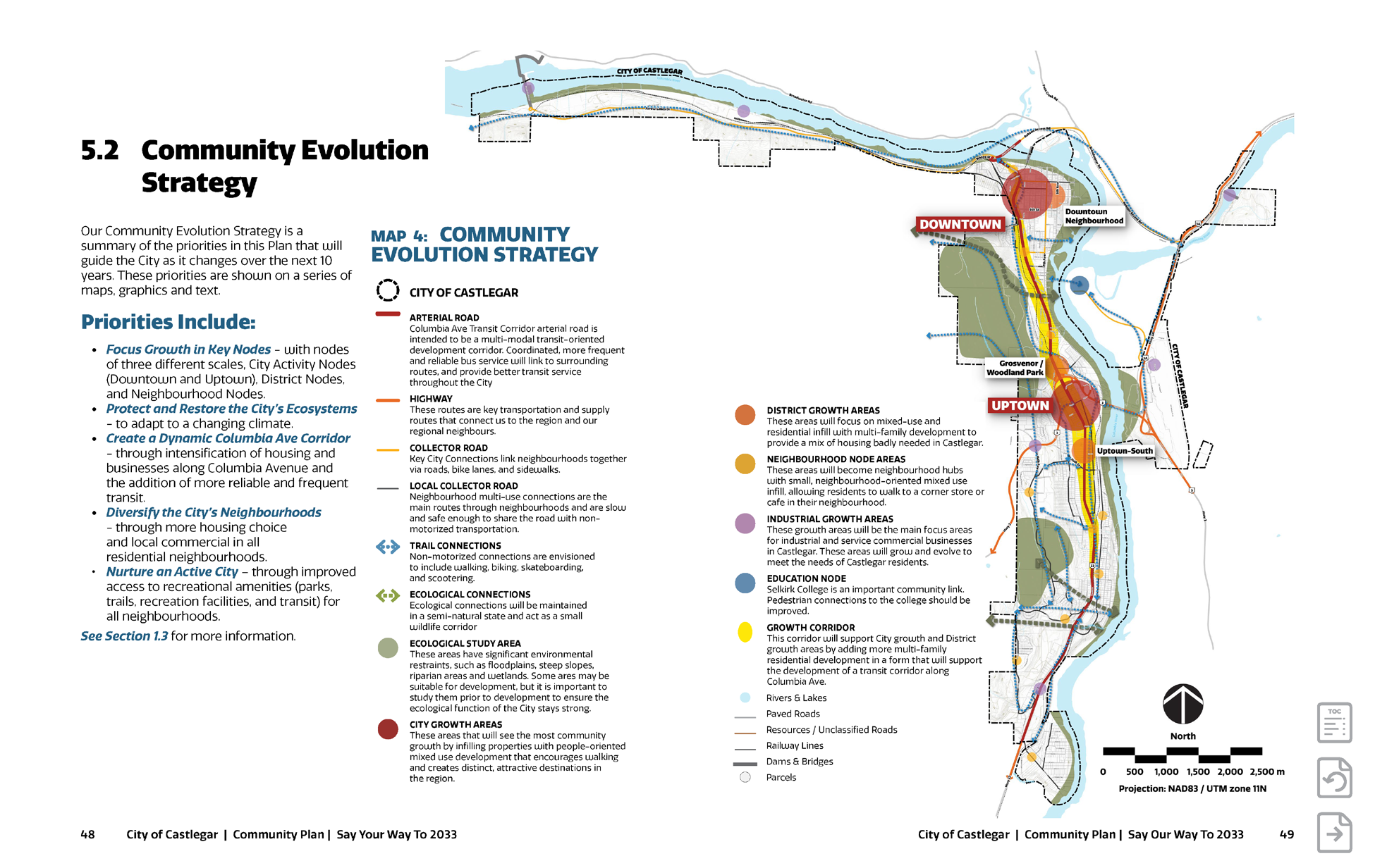
The Community Evolution Strategy map from the Castlegar Community Plan

05

Strategies & Implementation Plans

One subject, taken all the way to action

Focused plans that take a single question, such as housing, food security, climate resilience, or sustainability, from analysis through to funded, sequenced actions with someone's name beside each one.

A strategy is the easiest document to write badly, because a list of aspirations reads well and commits to nothing. We push every strategy through to the unglamorous part: who does it, what it costs, what year, and which grant pays for it.

What you get

  • Background research and best practice review
  • Community and stakeholder engagement
  • Prioritized recommendations
  • Implementation tables with cost and timing
  • Funding and grant alignment
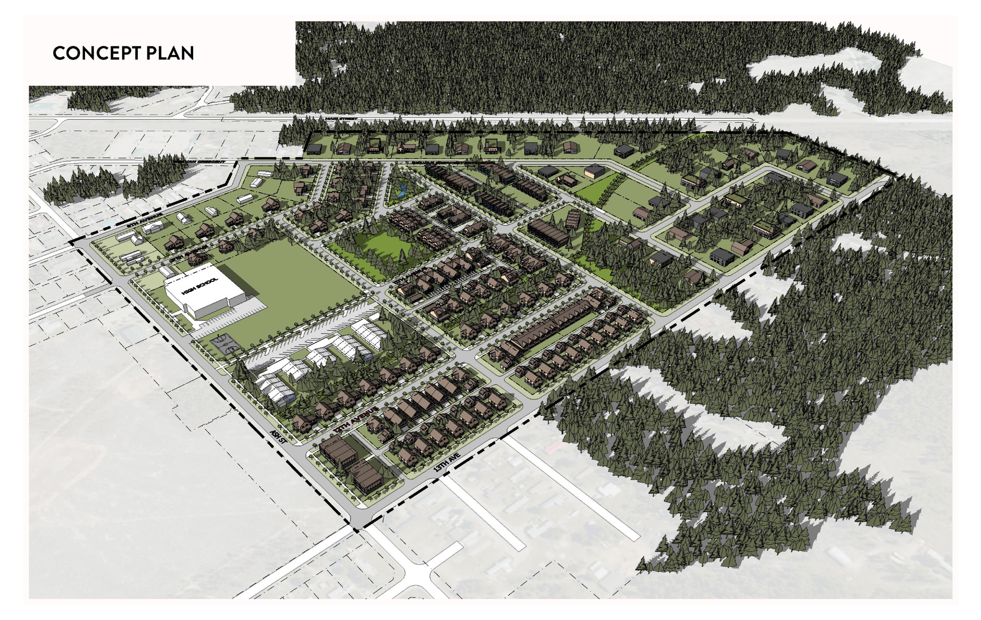
Aerial concept plan for Valemount, showing the proposed blocks, live and work units, community park, and industrial lots against the forest edge

06

3D Visualization

Seeing it before deciding on it

Three-dimensional models, massing studies, and illustrative renderings that show what a policy or a proposal will actually look like.

Most people cannot read a zoning bylaw, and nobody should have to in order to have an opinion about their own street. A model turns an abstract density figure into something a resident can react to and a Council can weigh, which usually produces a better decision and a shorter argument.

What you get

  • Massing and build-out models
  • Street-level illustrative views
  • Stylized renderings
  • Bylaw-testing visualizations
  • Images for open houses and Council reports
Community Evolution Strategy spread from the Castlegar Community Plan, with the priorities set out beside a map of growth areas, nodes, and corridors along the Columbia River

07

Mapping

The base every plan is built on

GIS-integrated mapping built for planning work: land use, zoning, constraints, steep slopes, riparian areas, infill capacity, and trail networks. We have a series of analysis we run to produce the information needed to understand a site or community, its constraints, and opportunities, and build our plans from a full knowledge base.

When mapping is subcontracted, the maps and the plan drift apart, and by adoption they disagree. Keeping it in-house means a land use change on Tuesday is a corrected map on Wednesday. It also means we can run the analysis, such as how much buildable land is actually left, rather than just illustrating someone else's answer.

What you get

  • Land use and zoning map series
  • Constraint and hazard mapping
  • Infill and land supply analysis
  • Trail and recreation mapping
  • Urban design analysis mapping
  • Print-ready and web map outputs
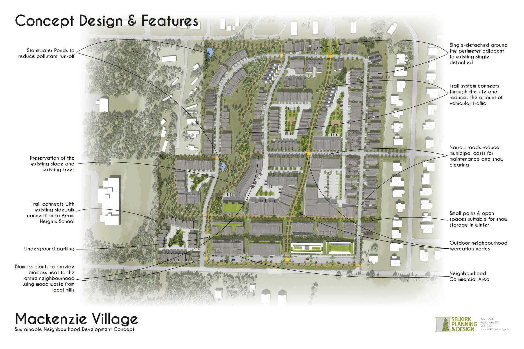
Annotated concept design for Mackenzie Village

08

Rezoning & Development Approvals

Getting a good project through the process

Support through rezoning, subdivision, and development permit applications, including the drawings, rationale, and public-facing material that carry an application through a Council process.

Having spent years writing the bylaws and sitting on the other side of the table, including seven years on Revelstoke's Advisory Planning Commission, we know what an application needs to answer before it is asked. That tends to shorten the process and sharpen the project.

What you get

  • Rezoning and OCP amendment applications
  • Subdivision and development permits
  • Planning rationale and policy analysis
  • Application drawings and renderings
  • Open house and Council presentation material

Our Mission

To help mountain communities bridge change while maintaining and enhancing a connection to place in a sustainable way.

Start a conversation →